The Middle Course~
POSTED BY Justin Chan 14FEB2011 5.45PM
Meanders
Hi! It is us again, posting this time from the middle course of the Ganges river. We are really grateful for the great weather. Without it, we would have been stuck along the upper course of the river.
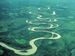
One thing that really defines the middle course of the river are the meanders.
It has always been fascinating to us how meanders are formed.
One thing that really defines the middle course of the river are the meanders.
It has always been fascinating to us how meanders are formed.

In general, meanders have shallow and deep areas. The shallow areas are called riffles and the deeper areas are called pools or concave banks. We have made it simple for you to understand, in the picture below.

POSTED BY Wilson Chng 16FEB2011 1.00M
As seen above, there are three main parts to a meander.
1) Inner bank
2) Concave bank/ pool
3) Riffle
The inner bank is where a lot of sediment build up occur. This depositing of sediment is due to the velocity of river water at the inner bank to be slower compared to that at the concave bank. Sediment built up at riffles and inner bends, cause the river to bend, as the water tries to avoid the deposition. The build up in deposition cause slip-off slopes to occur on the inner bank. (More on slip-off slopes will be covered later.)
The concave bank is where the river water "hits" before changing its direction. Since the concave bank is constantly hit by the constant high velocity of the river, a huge amount of erosion occurs at the concave bank. After time, a river cliff forms at this bank, due to the erosion. (More on river cliff will be covered later.)
Over time, the repetition of depositing sediments and eroding of concave banks cause the river bends to be more defined hence forming a meander.
Riffles are the portions of the river between each concave and inner bank. They are distinct in that they are relatively straight compared to the concave and inner banks which a characterized by huge 'U curves'.
POSTED BY DYLAN TING 19FEB2011 3.00PM
River Cliffs
Now that we have a better idea on how a river meander is generally formed, let's learn a little more about river cliffs. If you recall, we discussed just a while back, that a river cliff is formed due to the constant erosion that occurs at the concave bank of a river.
Let us first refer to a picture which will help you understand clearer.
Let us first refer to a picture which will help you understand clearer.
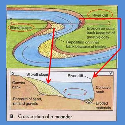
From the picture above, it is easy to see that due to the great velocity of the river water, More and more erosion occurs on the concave bank. This causes sand, silt and gravels on the concave bank to be washed off, leaving a steep river cliff.
POSTED BY Justin Chan 25FEB2011 8.00PM
Slip-off slope
A slip-off slope is what happens at the inner bank of the river. The inner bank is also known as the convex bank and its term will be used interchangeably. As explained in our discussion of meanders, Sand, silt and gravels get deposited on the inner bank of the river. The build up of these deposits form a slope on the convex bank. This slope is called a slip-off slope.
Please refer to the figure in the section on river cliffs to better understand how a slip-off slope looks like.
It is good to know that river cliffs and slip-off slopes are also found in the lower course of a river.
Please refer to the figure in the section on river cliffs to better understand how a slip-off slope looks like.
It is good to know that river cliffs and slip-off slopes are also found in the lower course of a river.
POSTED BY Wilson Chng 28FEB2011 4.00PM
It has been really tiring to go down the middle course of the river. At some point, the fast paced water seem to push you towards the concave sides of the meandering river. We are still quite a distance from the lower course of the river and the scene has been the same for quite some time.
Ox bow lakes
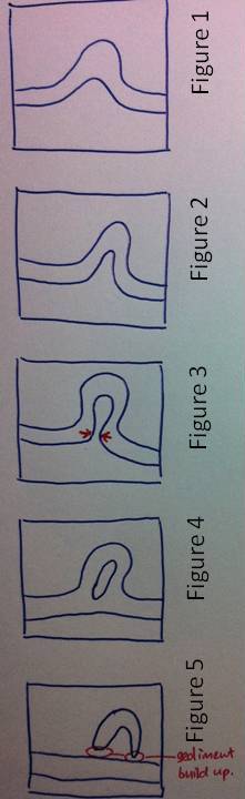
It is a rare sight, but we managed to catch a view of an ox bow lake! It looks really interesting when you understand how an ox bow lake is formed. Hmm... in case you were wondering, we shall include a picture of an ox bow lake, so you know how one looks like.

The small 'U' shaped lake circled in red in the picture above is called an ox bow lake.
As time passes, meanders lead to the formation of an ox bow lake. Well, you see... We learnt that the concave sides of a river is being constantly eroded. The continuous erosion at the concave sides cause the necks of the meander to become narrower. (see right: Figure 1, 2 and 3)
This continues to a stage where the neck breaks and a direct path allows most water to pass through without going through the meander.
Water will then take the shortest path, and hence choose the straight path. (see right: Figure 4)
As time goes by, deposition will seal off the old meander bend (this is also called a cut off), forming a straight river channel. The old meander bend that is left isolated will be called an ox bow lake! (see right: Figure 5)
Copyright© 2011
