The Upper Course~
POSTED BY Wilson Chng 30JAN2011 5.45PM
It has been almost 6 hours since the last time we posted about the waterfall. We are now taking a really nice comfortable break, leaning back on some rocks and just chatting about our plans for the next few weeks.
On the right is a picture of a gorge. A gorge is formed similar to a waterfall. It occurs at the upper course of a river. What really happens is that many years back (dating back to decades and centuries), the river water continues to flow pushing softer rocks, leaving behind only the harder rocks. The areas with softer rock continue to give way and is worn down by the constant flow of river water, resulting in a gap in the earth.
On the right is a picture of a gorge. A gorge is formed similar to a waterfall. It occurs at the upper course of a river. What really happens is that many years back (dating back to decades and centuries), the river water continues to flow pushing softer rocks, leaving behind only the harder rocks. The areas with softer rock continue to give way and is worn down by the constant flow of river water, resulting in a gap in the earth.

A Gorge
An animation of a gorge
Well we've decided, to simplify things for you so you wont get too confused with all these terms.

POSTED BY Justin Chan 30JAN2011 12.00PM
What a magnificent sight! We have finally reached the upper course of the Ganges River. From where we are, we can see waterfalls, gorges, and even a plunge pool. Hold it. Wait... let me get a picture of that waterfall for you.

A waterfall
This is really interesting, I got this image off wikipedia. It shows the cross section of a waterfall. In general, waterfalls are formed in 2 ways.
1) By erosion
2) by faulting
Erosion occurs when river water flows continuously over two layers of rock. Friction caused by the river water causes the weaker rocks to be washed off (see point (2)). We end up with a waterfall!
1) By erosion
2) by faulting
Erosion occurs when river water flows continuously over two layers of rock. Friction caused by the river water causes the weaker rocks to be washed off (see point (2)). We end up with a waterfall!


Faulting (2 plates sliding along each other and then breaking) can occur due to movement of the earth surfaces such as earthquakes. Example of faults:
When a fault occurs in the path of a river flow, a waterfall can be formed.

Oh well... Since we're talking about waterfalls, it'll be good to let you know that a plunge pool is often found at the bottom of a waterfall. Gravity causes the water to plunge down towards the weak rock at the base of the waterfall, causing a depression in the ground (see red arrow). This depression is called a plunge pool.
An animation of a waterfall forming
POSTED BY DYLAN TING 05FEB2011 12.30PM
As we were settling down for lunch, Wilson noticed a magnificent sight nearby, whitewater! Recalling our past year's geography lesson, we immediately recognized the whitewater as rapids!
Not only that, but there were people rafting on it! They look like they are having a terrible amount of fun!
I asked Justin to capure this video of the rafters.
The captured video of the rafters.
Oh! In the case you were wondering what rapids are and how they were formed...
Rapids are formed when the river flows over an area of alternate bends of resistant and less resistant rocks. Since less resistant rocks erode at a faster rate, a series of steps, at the base of the river would be formed. Hence, the river's water would be moving in a series of hopping motion.
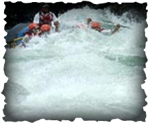
Rapids!

POSTED BY Wilson Chng 09FEB2011 10.00AM
Ahhh... We were so tired, none of us were able to update the rest of yesterday to you. It was eventful though. I personally enjoyed looking at the animals roam freely in the surrounding jungle. That, in itself is a rare sight for us Singaporeans.
Today, I hope to learn something new about the upper course river. Till then, bye!
Today, I hope to learn something new about the upper course river. Till then, bye!
POSTED BY JUSTIN CHAN 12FEB2011 3.00PM
Hello again, to all who are following our progress down the Ganges river. We just had lunch after a long day of kayaking down the river. Look at the picture just under this paragraph. From where we are, we can see a set of holes in the ground. In case you were wondering, whats so great about these round holes, These holes are potholes! Potholes are formed by corrasion; abrasion between the particles in the river.
The formation of these potholes are quite interesting. They are actually, rock fragments which are trapped in the river bed. When the river water swirl around these hollows at a high velocity, a swirling motion will occur, causing rock fragments to act as a drill, drilling round potholes into the river bed.
Some of the potholes here are huge! These potholes are probably the result of multiple potholes joining together to form what we see!

The Potholes!
According to the map, we are just a short distance from the middle course of the river. Till then, it seems the river will continue to be fast paced. It will be hard to take a break. So i doubt any of us will be able to post any time too soon. But fret not! We will take pictures of various interesting features along the river as we go along, and update this blog with the features as soon as we can. (:
Copyright© 2011
